The Gurage Zone of Ethiopia is located at the northern edge of Ethiopia's most diverse region, the Southern Nations, Nationalities, and Peoples' Region (SNNPR), which is home to 56 of Ethiopia's 82 distinct languages/ethnic groups. The Gurage Zone is the home of the Gurage people, who represent about 2 million of Ethiopia's approximately 88 million people. (wikipedia)
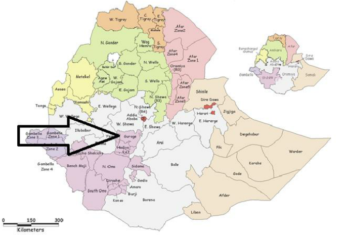
The arrow above points to the Gurage Zone of Ethiopia, the northernmost zone of the SNNPR (dark purple).
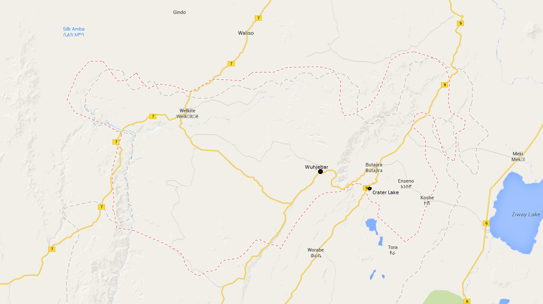
Map of the Gurage Zone
The city of Butajira is one of the administrative centers of the Gurage Zone. It is located about 120 kilometers South-Southwest of Addis Ababa and can be reached in about 3 hours on a bus.
Welkite is another administrative center about the same distance from Addis Ababa, though more to the Southwest. These two major towns in the region are growing quickly and are about 2 hours apart traveling via bus on the recently opened road that connects them. It is an impressive multi-million dollar highway that winds up and over the 12,000 ft. Mt. Gurage.
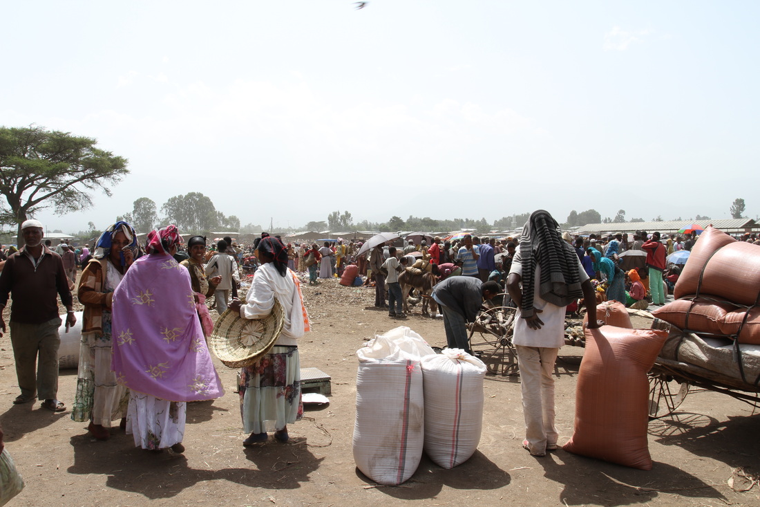
Butajira is located about 7,000 ft. above sea level near the edge of the Great Rift Valley. To the West, Mt. Gurage looms over the town, while the plains to the East feature a drier climate and eventually lead to Lake Ziway. Butajira is home to two hospitals, with another, Project Mercy Hospital, located about 10 kilometers to the West. The town is also home to a compound where mice are raised to provide blood serum. Butajira has an impressive market every Friday, attended by thousands of people from the surrounding area. A short 10 kilometers to the South lies an interesting volcanic crater lake with a nearby cave with a family living in it.
Welkite is another principal town in the Zone, albeit a little smaller and less traveled by tourists in comparison with Butajira.
Enseno and Koshe are two slightly smaller towns located to the East of Butajira on the road to Lake Ziway.
Wuhjebar is located on top of Mt. Gurage, near the eastern side of the mountain.
Welkite is another administrative center about the same distance from Addis Ababa, though more to the Southwest. These two major towns in the region are growing quickly and are about 2 hours apart traveling via bus on the recently opened road that connects them. It is an impressive multi-million dollar highway that winds up and over the 12,000 ft. Mt. Gurage.
Butajira is located about 7,000 ft. above sea level near the edge of the Great Rift Valley. To the West, Mt. Gurage looms over the town, while the plains to the East feature a drier climate and eventually lead to Lake Ziway. Butajira is home to two hospitals, with another, Project Mercy Hospital, located about 10 kilometers to the West. The town is also home to a compound where mice are raised to provide blood serum. Butajira has an impressive market every Friday, attended by thousands of people from the surrounding area. A short 10 kilometers to the South lies an interesting volcanic crater lake with a nearby cave with a family living in it.
Welkite is another principal town in the Zone, albeit a little smaller and less traveled by tourists in comparison with Butajira.
Enseno and Koshe are two slightly smaller towns located to the East of Butajira on the road to Lake Ziway.
Wuhjebar is located on top of Mt. Gurage, near the eastern side of the mountain.
|
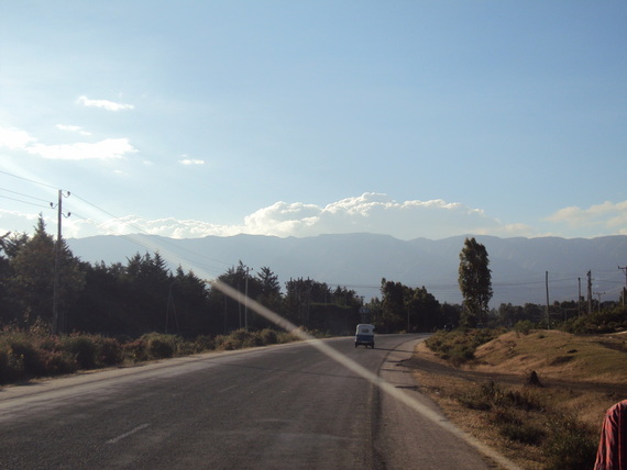
Looking West toward Mt. Gurage from Grar Bet Hospital in Butajira.
|
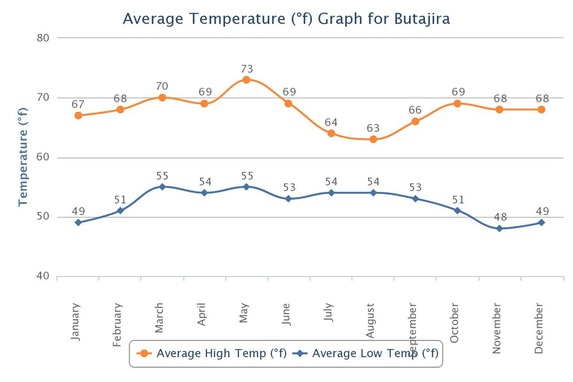
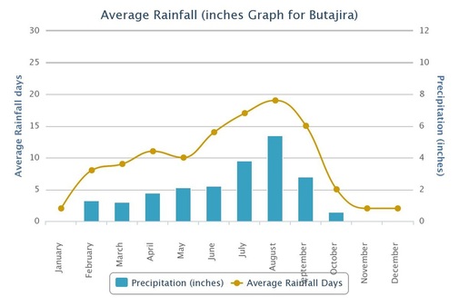
Climate
|
|
Avoid travel to the Gurage Zone especially in July and August. The best months to travel are October - April, when rains are nonexistent or relatively scarce.
